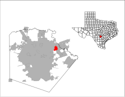
Live Oak, Texas
Live Oak, Texas | |
|---|---|
 Location of Live Oak, Texas | |
 | |
| Coordinates: 29°33′2″N 98°20′18″W / 29.55056°N 98.33833°W | |
| Country | |
| State | |
| County | Bexar |
| Government | |
| • Type | Council-Manager |
| • City Council | Mayor Mary M. Dennis Aaron Dahl (Pro-Tem) Mendell Morgan, Jr. Robert "Bob" Tullgren Dr. Erin Perez Ed Cimics |
| • City Manager | Anas Garfaoui |
| Area | |
| • Total | 4.80 sq mi (12.43 km2) |
| • Land | 4.76 sq mi (12.32 km2) |
| • Water | 0.04 sq mi (0.11 km2) |
| Elevation | 912 ft (278 m) |
| Population (2020) | |
| • Total | 15,781 |
| • Density | 3,468.36/sq mi (1,339.14/km2) |
| Time zone | UTC-6 (Central (CST)) |
| • Summer (DST) | UTC-5 (CDT) |
| ZIP codes | 78148, 78233 |
| Area code(s) | 210, 726 (planned) |
| FIPS code | 48-43096[3] |
| GNIS feature ID | 1340230[2] |
| ANSI Code | 2410847[4] |
| Website | liveoaktx.net |
Live Oak is a city in Bexar County, Texas, United States. The population was 15,781 at the 2020 census. It is part of the San Antonio Metropolitan Statistical Area.
Geography
[edit]According to the United States Census Bureau, Live Oak has a total area of 4.7 square miles (12 km2), of which 4.7 square miles (12 km2) is land and 0.04 square miles (0.10 km2) (0.64%) is water.
Demographics
[edit]| Race | Number | Percentage |
|---|---|---|
| White (NH) | 5,696 | 36.09% |
| Black or African American (NH) | 2,063 | 13.07% |
| Native American or Alaska Native (NH) | 48 | 0.3% |
| Asian (NH) | 697 | 4.42% |
| Pacific Islander (NH) | 60 | 0.38% |
| Some Other Race (NH) | 80 | 0.51% |
| Mixed/Multi-Racial (NH) | 667 | 4.23% |
| Hispanic or Latino | 6,470 | 41.0% |
| Total | 15,781 |
As of the 2020 United States census, there were 15,781 people, 6,135 households, and 3,940 families residing in the city. The population density was 1,956.7 inhabitants per square mile (755.5/km2). There were 3,518 housing units at an average density of 751.8 per square mile (290.3/km2). Of the 6,135 households 35.4% had children under the age of 18 living with them, 59.5% were married couples living together, 12.2% had a female householder with no husband present, and 24.4% were non-families. 19.7% of households were one person and 4.3% were one person aged 65 or older. The average household size was 2.67 and the average family size was 3.06.
The age distribution was 26.3% under the age of 18, 7.4% from 18 to 24, 31.1% from 25 to 44, 26.1% from 45 to 64, and 9.1% 65 or older. The median age was 36 years. For every 100 females, there were 94.2 males. For every 100 females age 18 and over, there were 88.8 males.
Climate
[edit]The climate in this area is characterized by hot, humid summers and generally mild to cool winters. According to the Köppen Climate Classification system, Live Oak has a humid subtropical climate, abbreviated "Cfa" on climate maps.[9]
Education
[edit]Live Oak is divided between two school districts: Judson Independent School District and North East Independent School District.[10]
The NEISD portion of Live Oak is zoned to Royal Ridge Elementary School,[11] White Middle School,[12] and Roosevelt High School.[13]
See also
[edit]Notes
[edit]References
[edit]- ^ "2019 U.S. Gazetteer Files". United States Census Bureau. Retrieved August 7, 2020.
- ^ a b U.S. Geological Survey Geographic Names Information System: Live Oak, Texas
- ^ "U.S. Census website". United States Census Bureau. Retrieved January 31, 2008.
- ^ "US Gazetteer Files 2016-Places-Texas". US Census. Retrieved January 24, 2017.
- ^ "Census of Population and Housing". Census.gov. Retrieved June 4, 2015.
- ^ "Explore Census Data". data.census.gov. Retrieved May 24, 2022.
- ^ https://www.census.gov/ [not specific enough to verify]
- ^ "About the Hispanic Population and its Origin". www.census.gov. Retrieved May 18, 2022.
- ^ Climate Summary for Live Oak, Texas
- ^ "2020 CENSUS - SCHOOL DISTRICT REFERENCE MAP: Bexar County, TX" (PDF). U.S. Census Bureau. Retrieved October 29, 2024. - Text list
- ^ "Elementary School Boundaries". North East Independent School District. Retrieved October 29, 2024.
- ^ "Middle School Boundaries". North East Independent School District. Retrieved October 29, 2024.
- ^ "High School Boundaries". North East Independent School District. Retrieved October 29, 2024.

